
HOW ICELAND'S RING ROAD WAS BUILT: THE STORY OF THE ROAD THAT CONNECTED AN ENTIRE ISLAND

Today, traveling around Iceland is surprisingly simple.
All you need to follow is one number. Route 1. Better known as the Ring Road, or Hringvegur in Icelandic, it takes you to almost all of Iceland's most famous attractions. Waterfalls, glaciers, volcanoes and picturesque fishing villages are all located just a short drive from it. Today, few people realize that just a few decades ago, this road didn't even exist. For a long time, driving all the way around Iceland was simply impossible.
Some parts of the country were cut off from the rest of the island for months at a time.

🛣️ EIGHT DAYS ON THE RING ROAD? I WOULDN'T DO IT AGAIN
Many first-time visitors to Iceland feel they have to drive the entire Ring Road and see everything the island has to offer.
I felt exactly the same.
I had ten days for my trip, with eight full days available for driving around the island. Looking back, I now know it was a mistake.
On some days I had to cover nearly 400 kilometres (250 miles).
That may not sound like much, but outside towns and villages the speed limit in Iceland is just 90 km/h (56 mph), and around almost every bend you'll find another waterfall, glacier, canyon or mountain that deserves a stop.
Because I was short on time, I often pulled over only briefly, took a few photographs and continued driving so I could reach my next accommodation before evening.

Back then, it was still possible to arrive at a guesthouse or campsite without making a reservation in advance.
Today, with tourism in Iceland at an entirely different level, that would be a risky strategy.
It was only after returning home that I realized driving the 1,322-kilometre (821-mile) Ring Road isn't simply about covering the distance.
It's a journey around one of the most beautiful islands on Earth.
If I were to do it again, I would allow myself at least eleven full days. Only then can you travel without rushing and truly experience Iceland instead of spending most of your holiday behind the steering wheel.
And yet, in a way, I'm complaining.
Less than a hundred years ago, Icelanders could only dream of making such a journey by car.
🐴 LESS THAN A HUNDRED YEARS AGO, ICELANDERS TRAVELLED ON HORSEBACK
At the beginning of the 20th century, Iceland was a completely different country.
Just over 80,000 people lived here, scattered along the coastline.
There were no roads in the modern sense connecting different parts of the island.
People travelled on foot, on horseback, or by boat along the coast.
If you wanted to travel from Reykjavík to eastern Iceland, you weren't looking at a comfortable drive of a few hours.
The journey could take several days.
Sometimes, bad weather made it impossible altogether.

🚜 THE FIRST ROADS WERE BUILT LITERALLY BY HAND
The first Icelandic roads were little more than improved tracks for horse-drawn carts.
Workers built them using shovels, pickaxes, and wheelbarrows.
The first signs of mechanization did not appear until the 1920s.
Despite this, the road network expanded rapidly.
In 1917, Iceland had approximately 500 kilometres of passable roads.
After the Second World War, that figure had grown to around 4,400 kilometres.
Yet one crucial connection was still missing:
A continuous route around the entire island.

🌊 THE GREATEST OBSTACLE WAS NOT THE MOUNTAINS — IT WAS THE GLACIAL RIVERS
On a map, the Ring Road looks simple.
In reality, it crosses some of Iceland’s most challenging terrain.
The greatest obstacle was the southeastern part of the island.
The vast sandy plain of Skeiðarársandur was created by sediments carried by glacial rivers flowing from Vatnajökull, Europe’s largest glacier.
The rivers constantly changed their courses.
After volcanic eruptions came devastating glacial floods known as jökulhlaups, which could sweep away everything in their path within just a few hours.
Building a road across this landscape was an enormous engineering challenge.
🌉 THE BRIDGES THAT UNITED ICELAND

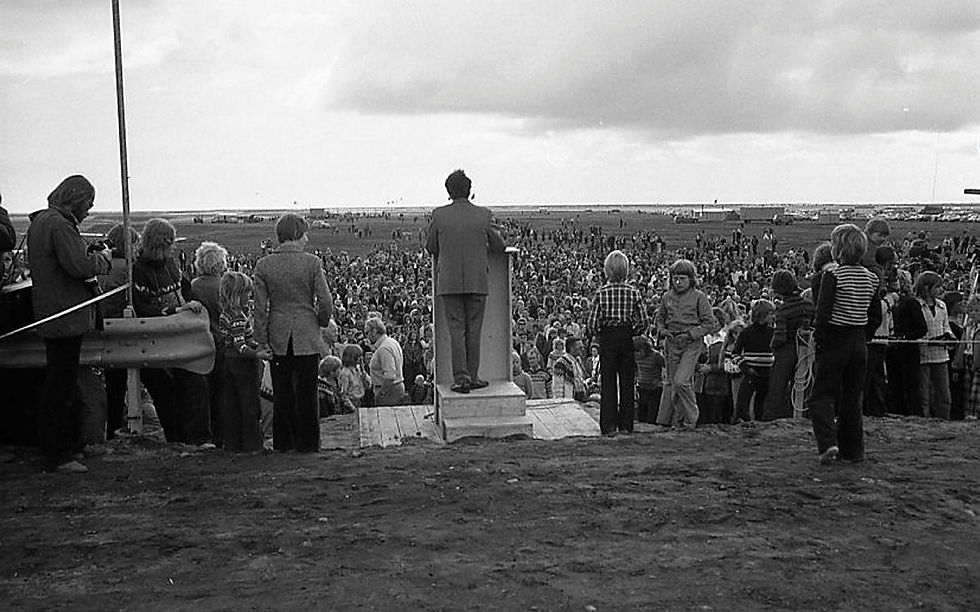
The decisive moment came in the early 1970s.
The Icelandic government decided to build several major bridges across the rivers of Skeiðarársandur.
After three years of construction, the final missing section was opened on 14 July 1974.
For the first time in history, it was possible to drive around the entire island on one continuous road.
The date was not chosen by accident.
The opening took place during celebrations marking 1,100 years since the first settlement of Iceland.
🛣️ THE RING ROAD WAS NOT YET THE ROAD WE KNOW TODAY
Many people assume that the entire road was paved immediately after it opened.
That was not the case.
Large sections were still gravel roads.
After rain, they turned into muddy tracks.
In summer, they produced clouds of dust.
Only over the following decades was the road gradually paved.
The final gravel section of the Ring Road disappeared as late as 2019.
That means that only a few years ago, visitors were still travelling parts of Iceland’s most important road on an unpaved surface.

🚗 TODAY, THE RING ROAD IS THE LIFELINE OF ICELAND
The road is approximately 1,322 kilometres long.
It connects almost all of the island’s larger towns.
Every day it carries supplies, buses, tourists, and local residents.
For Iceland, it plays a role similar to that of motorways in other countries.
Without the Ring Road, modern Iceland would look completely different.
🌋 EVEN TODAY, THE ROAD HAS NOT FULLY CONQUERED NATURE
The Ring Road may be a modern highway, but in Iceland nature still has the final say.

Heavy snowstorms, landslides, volcanic eruptions, and glacial floods can close the road within hours.
That is why Iceland’s road authorities monitor it around the clock and invest every year in upgrading bridges and improving vulnerable sections.
CONCLUSION: THE ROAD THAT CHANGED ICELAND
When you drive along the Ring Road today, it is easy to imagine that it has always been there.
In reality, it is surprisingly young.
Just fifty years ago, it was impossible to drive all the way around Iceland.
And only a few years ago, parts of the route still required slowing down on gravel roads.
Perhaps that is why the Ring Road is much more than just a road.
It is a symbol of how an isolated island became a modern nation — one that managed to connect its people despite volcanoes, glaciers, and an unpredictable natural environment.

About the Author
Iceland has fascinated me for many years. Over the course of numerous journeys across the island, I have driven tens of thousands of kilometers, experienced storms that changed travel plans within minutes, and witnessed days when choosing the right route meant discovering places that most visitors never see. I documented many of these experiences in my documentary film Island in the North.
Through this website, I share practical travel advice, up-to-date information, and firsthand experiences from the field to help others explore Iceland more safely and gain a deeper understanding of its unique landscapes and ever-changing nature.


Komentáře